Category:Lovells Island
Jump to navigation
Jump to search
island in Suffolk County, Massachusetts, United States of America  | |||||
| Upload media | |||||
| Instance of | |||||
|---|---|---|---|---|---|
| Location | Suffolk County, Massachusetts | ||||
| Located in or next to body of water | |||||
| Area |
| ||||
 | |||||
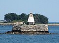
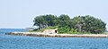
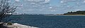
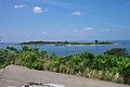
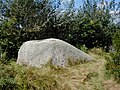
English: Lovells Island is a 62-acre (250,000 m2) island in the Boston Harbor Islands National Recreation Area, in Massachusetts. It is named after Captain William Lovell, who was an early settler of nearby Dorchester. The island is known as the site of several shipwrecks, including the 74-gun French warship Magnifique in 1782. Once the home of the Lovells Island Range Lights, the island was a buoy tending station in the early 20th century and was fortified before and during World War I, with remains of Fort Standish, active 1902-1946, still visible. Today, Lovells Island is a popular camping island, with picnic areas and walking trails through its dunes and woods, together with a non-supervised swimming beach. On weekends and summer weekdays, it is served by a shuttle boat to and from Georges Island, connecting there with ferries to Boston and Quincy.
Media in category "Lovells Island"
The following 12 files are in this category, out of 12 total.
-
 2017 Boston Harbor marker and Lovells Island.jpg 3,935 × 2,881; 1.34 MB
-
 2017 Lovells Island from Boston Harbor 1.jpg 4,608 × 2,443; 1.61 MB
-
 2017 Lovells Island from Boston Harbor 2.jpg 4,090 × 2,950; 1.9 MB
-
 2017 Lovells Island from Boston Harbor 3.jpg 3,487 × 1,603; 1.08 MB
-
 2017 Lovells Island from Boston Harbor 4.jpg 4,608 × 2,740; 1.59 MB
-
 Batt Williams.jpg 1,280 × 960; 395 KB
-
 Lovells Deer Georges Islands BostonHarbor 2009.jpg 3,446 × 1,160; 868 KB
-
 Lovells Island in Boston Harbor.JPG 2,160 × 1,440; 768 KB
-
 Lovells Island Sign.JPG 4,000 × 3,000; 2.59 MB
-
 LovellsIsland GeorgesIsland BostonHarbor 2009.jpg 3,283 × 506; 506 KB
-
 LovellsIsland3 BostonHarbor 2009.jpg 3,591 × 1,065; 739 KB
-
 Lovers rock.jpg 1,280 × 960; 419 KB


